Seismic Resolution — Vertical & Horizontal
Seismic Resolution — Vertical & Horizontal
Introduction
Resolution determines how small a geological feature seismic data can detect. Understanding vertical and horizontal resolution is essential for interpreting thin beds, faults, and stratigraphic features. These limits define what seismic can and cannot reveal — helping interpreters avoid over‑interpretation.
1. Vertical Resolution
Vertical resolution is controlled primarily by the seismic wavelet.
Quarter‑Wavelength Rule
A layer must be at least ¼ of the dominant wavelength thick to be resolved as a separate reflector. Thinner beds may still produce tuning effects, but they cannot be individually distinguished.
Vertical resolution depends on:
Dominant frequency
Velocity
Wavelet shape
Higher frequencies = better vertical resolution.
2. Horizontal Resolution
Horizontal resolution is influenced by:
A. Fresnel Zone
Defines the area over which seismic energy spreads. A smaller Fresnel zone = better horizontal resolution.
B. Migration
Migration collapses diffractions and improves lateral clarity.
C. Acquisition Geometry
Source/receiver spacing and line layout affect the ability to resolve small lateral features.
Horizontal resolution determines how well seismic can image:
Channels
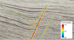
Faults
Stratigraphic edges
Small structural features
3. Improving Resolution
Several processing and acquisition techniques enhance seismic resolution:
Deconvolution — sharpens the wavelet
Broadband processing — extends frequency bandwidth
Spectral decomposition — highlights thin beds and stratigraphy
High‑density acquisition — improves spatial sampling
These methods help interpreters see finer geological detail.
Conclusion
Resolution limits what seismic can reveal. Understanding vertical and horizontal resolution helps interpreters avoid over‑interpretation and recognize when features are real — or simply artifacts of the data. Better resolution leads to clearer images, more accurate interpretations, and reduced uncertainty.