Horizon Tracking with Physics Guided AI
Horizon Tracking with Physics Guided AI
Introduction
Horizon interpretation is fundamental to seismic analysis. It defines stratigraphy, reservoir boundaries, and structural frameworks. Manual horizon picking is slow and subjective, while traditional AI models often struggle with discontinuities or noisy data.
Physics Guided AI (PG AI) provides a powerful solution by combining machine learning with geological rules.
1. Why Horizon Tracking Is Difficult
Challenges include:
Variable reflector strength
Fault offsets
Noise and multiples
Stratigraphic complexity
Lateral facies changes
AI models must understand both local and regional geological context.
2. How Physics Guided AI Enhances Horizon Tracking
PG AI incorporates:
Dip limits
Continuity rules
Stratigraphic relationships
Amplitude behavior
This ensures that horizons follow realistic geological patterns rather than noise or artifacts.
3. Horizon Tracking Workflow
Stage 1: Data Preparation
Seismic volumes are conditioned and normalized to ensure consistent amplitude and phase behavior.
Stage 2: Feature Engineering
Attributes used for horizon tracking include:
Dip
Instantaneous phase
Envelope
Spectral decomposition
These features help the model understand reflector geometry and continuity.
Stage 3: Physics Constraints
Rules ensure:
Continuous reflectors
Realistic dip changes
Proper fault offsets
Stratigraphic consistency
These constraints prevent unrealistic horizon shapes.
Stage 4: Model Training
The model learns horizon patterns while respecting physics‑based rules and geological context.
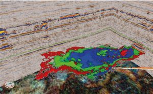
Stage 5: Inference
The model outputs:
Horizon probability volumes
Auto‑tracked surfaces
These results dramatically accelerate interpretation.
Stage 6: QC
Interpreters validate and adjust the results to ensure geological accuracy.
Stage 7: Refinement
Models are iteratively improved based on QC feedback.
Stage 8: Deliverables
Outputs include:
Horizon surfaces
Probability volumes
Interpretation layers
Conclusion
Physics Guided AI dramatically accelerates horizon interpretation while maintaining geological realism. It reduces manual effort, improves consistency, and enhances reservoir understanding.