Seismic Interpretation — Fundamentals
Seismic Interpretation — Fundamentals
Author: Your Name Published: April 2026 Category: Seismic Data Management → Interpretation
Introduction
Seismic interpretation is the art and science of extracting geological meaning from seismic data. It transforms seismic reflections into an understanding of the subsurface — mapping faults, horizons, stratigraphy, and reservoir architecture. Interpretation sits at the center of exploration and development, guiding drilling decisions and reducing geological uncertainty.
This article explains the fundamentals of seismic interpretation, the workflows involved, and the skills required to interpret seismic data effectively.
1. What Is Seismic Interpretation?
Seismic interpretation is the process of analyzing seismic data to identify:
Structural features (faults, folds, salt bodies)
Stratigraphic features (channels, pinchouts, unconformities)
Reservoir geometry
Lithology and fluid indicators
Basin evolution
Interpretation integrates seismic data with:
Well logs
Geological models
Core data
Production history
Attributes and inversion
The goal is to build a coherent geological model that explains the seismic response.
2. The Interpretation Workflow
A. Data Familiarization
Interpreters begin by understanding:
Survey coverage
Processing history
Data quality
Key horizons and structural trends
This sets the foundation for accurate interpretation.
B. Horizon Interpretation
Horizon picking involves:
Identifying continuous reflectors
Tracking them across the volume
Handling faults and discontinuities
Building structural frameworks
Horizon interpretation defines stratigraphy and reservoir boundaries.
C. Fault Interpretation
Faults are interpreted using:
Vertical sections
Time slices
Coherence and curvature attributes
Fault‑probability volumes (AI‑assisted)
Fault interpretation is essential for structural mapping and reservoir compartmentalization.
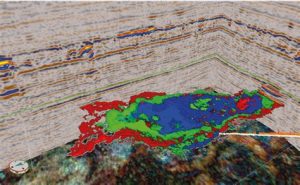
D. Attribute Analysis
Attributes highlight:
Faults
Fractures
Channels
Lithology changes
Attributes guide interpreters toward subtle geological features.
E. Integration with Well Data
Well logs provide:
Lithology
Porosity
Fluid contacts
Checkshot ties
This ensures seismic interpretations are grounded in physical measurements.
F. Building the Geological Model
The final model includes:
Structural framework
Stratigraphic architecture
Reservoir geometry
Facies distribution
This model supports reservoir characterization and development planning.
3. Tools and Technologies in Interpretation
3D visualization
Seismic attributes
Inversion
Machine learning
Physics‑guided AI
Automated horizon and fault extraction
Modern interpretation blends human expertise with advanced technology.
4. Challenges in Interpretation
Noise and multiples
Poor data quality
Complex geology
Velocity uncertainty
Interpreter bias
QC and cross‑disciplinary collaboration help mitigate these challenges.
Conclusion
Seismic interpretation is a critical skill in geoscience. By combining seismic data, attributes, well logs, and geological knowledge, interpreters build accurate subsurface models that guide exploration and development decisions.